
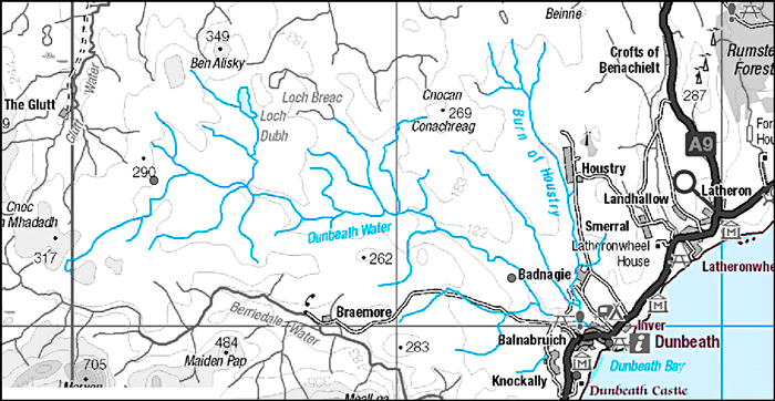
The Dunbeath Water flows for 20km from its source at the 300m contour of Loch Braigh na h-
Water quality is monitored monthly by SEPA (see Appendix 1), including measures of flow, suspended solids, pH, conductivity, calcium carbonates and hardness, oxygen levels, nitrates and nitrites, chloride, silicate, sulphate and sulphite, as well as a range of individual elements (Na, K, Ca, Mg, Fe, Al, Mn, Cd, Cr, Cu, Ni, Pb, Zn, As, V, Co, Sn, and Hg).
There is thus intense hydrological surveying for adverse pollutant events, but water quality has remained high throughout, with SEPA reporting on the Dunbeath catchment:
‘The Dunbeath Water catchment contains five water bodies. The Dunbeath Water – Burn of Houstryto sea is at high ecological status. The remaining four are at good status; Dunbeath Water – Raffin Burn to Burn of Houstry, Dunbeath Water – source of Raffin Burn, Raffin Burn and Burn of Houstry. The Dunbeath Water catchment includes the Dunbeath Water Freshwater Fish designated area which is meeting the required standards with respect to the Water Framework Directive.’
North Highland Area Management Plan Catchment Summaries. September 2010.
PHYSICAL DESCRIPTION OF DUNBEATH WATER AND CATCHMENT
Ownership and Management Structure
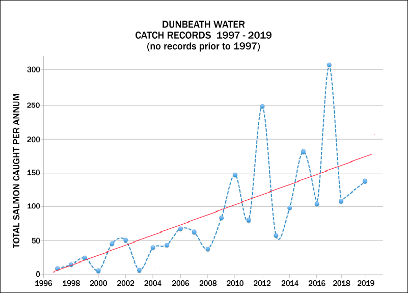
The River and its catchment area have been in the single ownership of Dunbeath Estate for many centuries. The Dunbeath Estate, including the river and catchment, is currently owned and managed by Mr and Mrs S.W.M Threipland. During the ownership of the Sinclair, Currie, Blythe and Avery families, Dunbeath Water was used as an adjunct of the general Estate for occasional salmon fishing during the summer months. Netting of salmon was left to the village of Dunbeath on a rental agreement from the Estate. Since coming under Threipland ownership in 1997, the river has received considerable attention and investment, coinciding with dramatic improvements in catch rates from 9 fish in 1997, to 177 in 2012.
Dunbeath Water is a member and part of the Caithness and District Salmon Fishery Board (CDFB, http://caithness.dsfb.org.uk/). CDFB is in the process of, together with the Northern Board (Halladale and Naver, http://northern.dsfb.org.uk/), initiating a Flow Country Rivers Trust. The FCRT’s role is ‘To advance for public benefit the conservation and enhancement of native freshwater fish (including migratory salmonids) and their environments (to include the flora and fauna proximate to the rivers and stillwaters) primarily but not limited to the inland and coastal waters connected to or forming a part of the ‘Flow Country’ of Caithness and Eastern Sutherland including but not limited to the jurisdictional areas of the Caithness and Northern District Salmon Fishery Boards. This alliance will allow greater critical mass in tackling some of the broader environmental issues that face this unique part of Scotland such as underwater turbines in the Pentland Firth and Wick Offshore Wind Farms etc.
Social and Economic Value
Dunbeath Estate is a working highland estate employing people who are local to the area. A small part of Estate income derives from paying guests who come to Dunbeath to fish for salmon and sea trout, and appreciate and enjoy the undisturbed natural habitat of this spate river. Most guests are confirmed regulars, coming from all over the UK and beyond. In addition to Estate guests, the local Angling Club generates a minor income, but considerable social benefits. The Estate also owns the right to conduct estuary netting, which was pursued quite vigorously until the 1980s with both fixed engine and sweep and cobble nets. The Estate recently purchased a new cobble boat and equipment, and occasionally does some very limited netting (maximum of 100 fish per season), partly to preserve the tradition and the ability to net if the situation required it, but also to harvest a sustainable catch for locals and the Estate.
Ecology of the River and Catchment
The majority of the catchment providing water to the river comes from upland Flow Country, Europe’s largest blanket bog, and lying within the Caithness and Sutherland Peatlands Special Protection Area. This area remains relatively undisturbed by development or human activity, and retains the essential combination of gentle topography, acidic substrates, and cool and humid conditions to allow the development and maintenance of ombrotrophic bog.
At the head of the river are two freshwater lochs with traditional hatches: Loch Dhu and Loch Braec. The lochs reside within a large, generally oligotrophic, drainage system which characterises this part of the northern Highlands. Rainfall run-
As the Dunbeath Water grows, it flows from blanket bog and peatland onto more nutrient-
The Dunbeath Salmon and Fishery
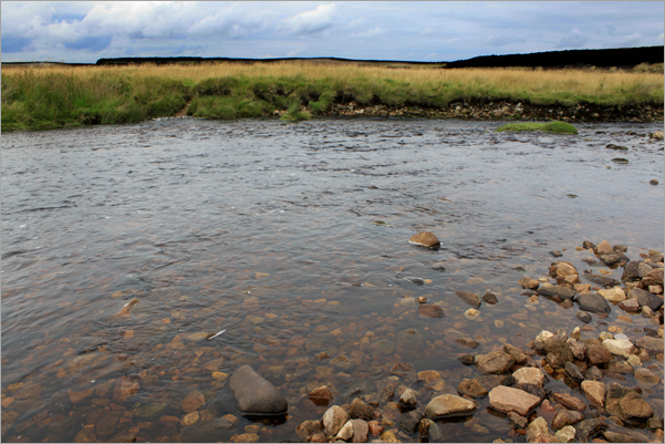
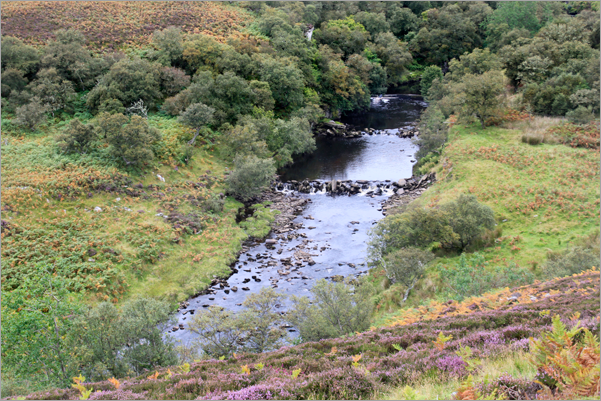
The Dunbeath Water is a typical highland spate river, experiencing a wide range of short-
Juvenile habitat for salmon fry and parr exists across most of the system, apart from some deeper, peat-
The life history of Dunbeath salmon involves a spawning window that typically occurs in November. Juveniles then usually spend 2 to 3 years in the river, followed by 1 to 3 years at sea, returning as either grilse or 2 to 3 sea-
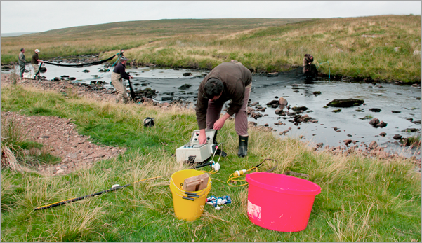
Detailed electro-
Centre personnel carried out an electro survey in August 2013 to establish juvenile abundance and structure. Electro-
Catch records of both rod-
In the last 16 years, a number of inputs have worked to maintain the traditional ecological health of the Dunbeath Water. The costs of management, which include re-
As well as collecting catch records to inform on seasonal trends and angling sustainability, the bailiff enforces local Angling Club rules. These currently stipulate: fly-
Recent Management
The River below Falls Pool / Claire's Pool
Redds above Achnaclyth
Electrofishing
For ten years (1998–2008), fry stock was purchased and introduced to the river to aid the depleted natural stock. The average annual bought fry introduction was 30,000 fed-
In 2009 the owners decided to invest in their own small hatchery program, since the old corn Mill adjacent to the lower river (under the A9 bridge) was being renovated into upstairs offices. The basement had its own river water supply and ideal space for hatchery activities. A local hatchery would use native Dunbeath salmon, and allow careful and specific restocking in line with troughs in adult spawning, and act as an important reservoir for eggs and fry in seasons experiencing exceptionally high or low flows.
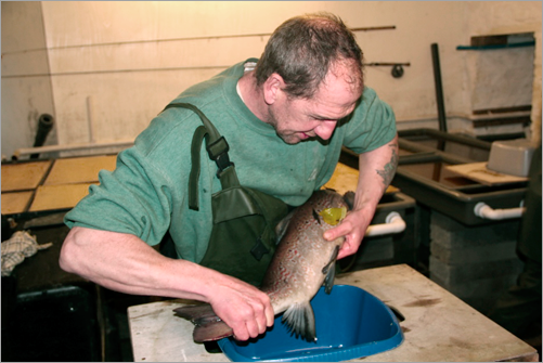
Stripping Salmon
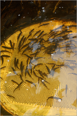
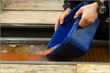
Fry being taken on to Smolting
Mac Young, a founder of the Angling Club and senior river bailiff, was employed to develop and run the hatchery, with much advice and help from experienced operators on the nearby Helmsdale, Thurso and Wick rivers. The hatchery has restocked native Dunbeath salmon (created from a small catch of broodstock late in the season) at unfed, fed and parr life stages. The fish are restocked in areas known to support salmon, and especially in areas when low numbers of adults were recorded on traditional spawning redds. In 2013, DNA was sampled from all adult broodstock, with a view to genotyping returning fish five years hence, and therefore to evaluate the effectiveness of hatchery restocking to successful returning spawners, as well as beginning a historical genebank for future assessments of genetic variation.
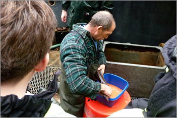
Mac stripping hens
Pouring out the fertiiised eggs
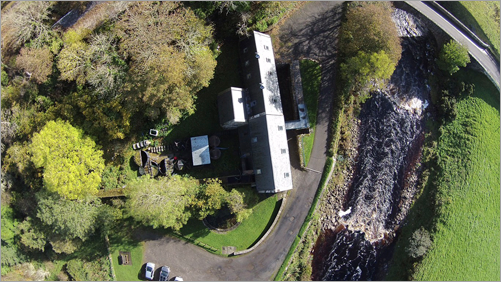
The Mill with the Hatchery behind
| HATCHERY |
| HATCHERY REPORTS |
| Management |
| Foreword |
| Dunbeath Water |
| Risk Assessment |
| Appendices |
| Education |